|
|
|||||||||||||||||
| Point ID: 7351 | Downloads | Plots | Site Data | Code: 70098 |
|
|
|||||||||||||||||
| Download | |
|---|---|
| Site Descriptor Information | Site Time Series Data |
| Link to all available data | |
| View: | Time Series | All |
| Units: | mm |
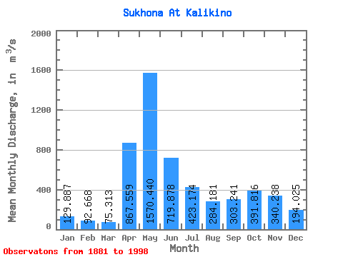
| Statistic | Jan | Feb | Mar | Apr | May | Jun | Jul | Aug | Sep | Oct | Nov | Dec | Annual |
|---|---|---|---|---|---|---|---|---|---|---|---|---|---|
| Mean | 129.89 | 92.67 | 75.31 | 867.56 | 1570.44 | 719.88 | 423.17 | 284.18 | 303.24 | 391.82 | 340.24 | 194.03 | 437.63 |
| Standard Deviation | 56.55 | 42.37 | 41.65 | 503.51 | 544.76 | 280.24 | 208.20 | 158.22 | 214.80 | 233.46 | 213.25 | 94.39 | 107.00 |
| Min | 32.30 | 21.60 | 21.60 | 59.60 | 401.00 | 204.00 | 155.00 | 66.40 | 39.80 | 43.40 | 80.90 | 34.20 | 247.20 |
| Max | 277.00 | 202.00 | 340.00 | 1930.00 | 3470.00 | 1650.00 | 1100.00 | 974.00 | 1010.00 | 1110.00 | 1160.00 | 515.00 | 707.50 |
| Coefficient of Variation | 0.43 | 0.46 | 0.55 | 0.58 | 0.35 | 0.39 | 0.49 | 0.56 | 0.71 | 0.60 | 0.63 | 0.49 | 0.24 |
 Return to R-Arctic Net Home Page