|
|
|||||||||||||||||
| Point ID: 7350 | Downloads | Plots | Site Data | Code: 70091 |
|
|
|||||||||||||||||
| Download | |
|---|---|
| Site Descriptor Information | Site Time Series Data |
| Link to all available data | |
| View: | Time Series | All |
| Units: | mm |
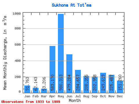
| Statistic | Jan | Feb | Mar | Apr | May | Jun | Jul | Aug | Sep | Oct | Nov | Dec | Annual |
|---|---|---|---|---|---|---|---|---|---|---|---|---|---|
| Mean | 91.76 | 62.14 | 53.21 | 583.17 | 980.31 | 479.28 | 284.66 | 208.35 | 202.96 | 249.62 | 225.49 | 151.26 | 297.69 |
| Standard Deviation | 45.57 | 30.41 | 37.08 | 303.93 | 336.05 | 229.33 | 152.39 | 123.18 | 126.86 | 153.31 | 136.69 | 130.03 | 81.93 |
| Min | 17.20 | 16.60 | 15.60 | 50.70 | 250.00 | 159.00 | 130.00 | 96.80 | 77.60 | 69.10 | 31.90 | 22.80 | 169.75 |
| Max | 217.00 | 137.00 | 284.00 | 1360.00 | 1750.00 | 1280.00 | 769.00 | 809.00 | 673.00 | 665.00 | 581.00 | 1040.00 | 516.33 |
| Coefficient of Variation | 0.50 | 0.49 | 0.70 | 0.52 | 0.34 | 0.48 | 0.54 | 0.59 | 0.62 | 0.61 | 0.61 | 0.86 | 0.28 |
 Return to R-Arctic Net Home Page