|
|
|||||||||||||||||
| Point ID: 7336 | Downloads | Plots | Site Data | Code: 70013 |
|
|
|||||||||||||||||
| Download | |
|---|---|
| Site Descriptor Information | Site Time Series Data |
| Link to all available data | |
| View: | Time Series | All |
| Units: | mm |
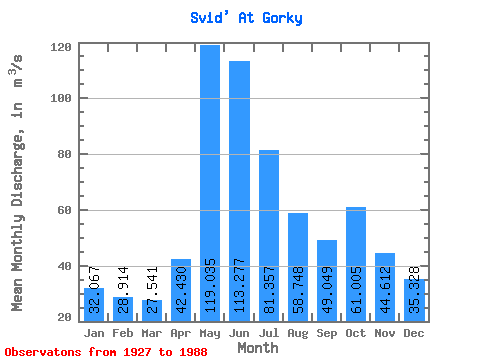
| Statistic | Jan | Feb | Mar | Apr | May | Jun | Jul | Aug | Sep | Oct | Nov | Dec | Annual |
|---|---|---|---|---|---|---|---|---|---|---|---|---|---|
| Mean | 32.07 | 28.91 | 27.54 | 42.43 | 119.03 | 113.28 | 81.36 | 58.75 | 49.05 | 61.01 | 44.61 | 35.33 | 59.46 |
| Standard Deviation | 14.58 | 12.20 | 10.09 | 17.55 | 32.65 | 33.50 | 25.66 | 18.12 | 17.16 | 89.61 | 20.64 | 15.48 | 15.17 |
| Min | 10.70 | 11.10 | 12.10 | 17.80 | 46.00 | 55.50 | 40.50 | 29.00 | 24.60 | 19.00 | 13.10 | 13.90 | 32.73 |
| Max | 64.80 | 55.50 | 46.90 | 103.00 | 202.00 | 211.00 | 168.00 | 106.00 | 130.00 | 712.00 | 107.00 | 72.80 | 102.66 |
| Coefficient of Variation | 0.46 | 0.42 | 0.37 | 0.41 | 0.27 | 0.30 | 0.32 | 0.31 | 0.35 | 1.47 | 0.46 | 0.44 | 0.26 |
 Return to R-Arctic Net Home Page