|
|
|||||||||||||||||
| Point ID: 7335 | Downloads | Plots | Site Data | Code: 70007 |
|
|
|||||||||||||||||
| Download | |
|---|---|
| Site Descriptor Information | Site Time Series Data |
| Link to all available data | |
| View: | Time Series | All |
| Units: | mm |
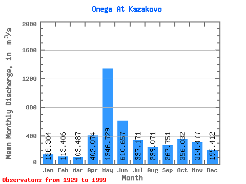
| Statistic | Jan | Feb | Mar | Apr | May | Jun | Jul | Aug | Sep | Oct | Nov | Dec | Annual |
|---|---|---|---|---|---|---|---|---|---|---|---|---|---|
| Mean | 138.30 | 113.41 | 103.49 | 402.07 | 1346.73 | 610.66 | 337.17 | 239.07 | 267.75 | 356.03 | 314.48 | 195.41 | 367.15 |
| Standard Deviation | 39.59 | 31.94 | 29.05 | 294.98 | 408.78 | 209.88 | 112.61 | 105.28 | 160.30 | 184.34 | 156.60 | 79.42 | 77.35 |
| Min | 60.70 | 53.00 | 52.30 | 60.80 | 652.00 | 277.00 | 140.00 | 110.00 | 98.60 | 98.20 | 90.70 | 73.00 | 219.90 |
| Max | 249.00 | 186.00 | 205.00 | 1300.00 | 2430.00 | 1420.00 | 643.00 | 684.00 | 852.00 | 830.00 | 659.00 | 472.00 | 559.33 |
| Coefficient of Variation | 0.29 | 0.28 | 0.28 | 0.73 | 0.30 | 0.34 | 0.33 | 0.44 | 0.60 | 0.52 | 0.50 | 0.41 | 0.21 |
 Return to R-Arctic Net Home Page