|
|
|||||||||||||||||
| Point ID: 7326 | Downloads | Plots | Site Data | Code: 49136 |
|
|
|||||||||||||||||
| Download | |
|---|---|
| Site Descriptor Information | Site Time Series Data |
| Link to all available data | |
| View: | Time Series | All |
| Units: | mm |
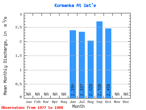
| Statistic | Jan | Feb | Mar | Apr | May | Jun | Jul | Aug | Sep | Oct | Nov | Dec | Annual |
|---|---|---|---|---|---|---|---|---|---|---|---|---|---|
| Mean | 2.39 | 2.34 | 2.03 | 2.71 | 2.46 | ||||||||
| Standard Deviation | 1.40 | 2.40 | 1.25 | 1.94 | 0.66 | ||||||||
| Min | 0.87 | 0.59 | 0.42 | 0.49 | 1.54 | ||||||||
| Max | 4.05 | 9.28 | 4.06 | 7.60 | 3.00 | ||||||||
| Coefficient of Variation | 0.59 | 1.03 | 0.62 | 0.72 | 0.27 |
 Return to R-Arctic Net Home Page