|
|
|||||||||||||||||
| Point ID: 731 | Downloads | Plots | Site Data | Code: 07FD008 |
|
|
|||||||||||||||||
| Download | |
|---|---|
| Site Descriptor Information | Site Time Series Data |
| Link to all available data | |
| View: | Time Series | All |
| Units: | mm |
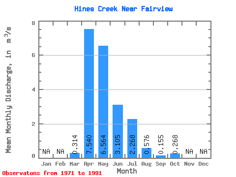
| Statistic | Jan | Feb | Mar | Apr | May | Jun | Jul | Aug | Sep | Oct | Nov | Dec | Annual |
|---|---|---|---|---|---|---|---|---|---|---|---|---|---|
| Mean | 0.31 | 7.54 | 6.56 | 3.10 | 2.27 | 0.58 | 0.15 | 0.27 | |||||
| Standard Deviation | 0.61 | 9.58 | 6.76 | 3.16 | 4.25 | 0.89 | 0.32 | 0.45 | |||||
| Min | 0.00 | 0.40 | 0.10 | 0.17 | 0.00 | 0.00 | 0.00 | 0.00 | |||||
| Max | 2.53 | 43.80 | 29.60 | 12.80 | 18.70 | 3.31 | 1.09 | 1.64 | |||||
| Coefficient of Variation | 1.96 | 1.27 | 1.03 | 1.02 | 1.88 | 1.55 | 2.08 | 1.68 |
 Return to R-Arctic Net Home Page