|
|
|||||||||||||||||
| Point ID: 7308 | Downloads | Plots | Site Data | Code: 49099 |
|
|
|||||||||||||||||
| Download | |
|---|---|
| Site Descriptor Information | Site Time Series Data |
| Link to all available data | |
| View: | Time Series | All |
| Units: | mm |
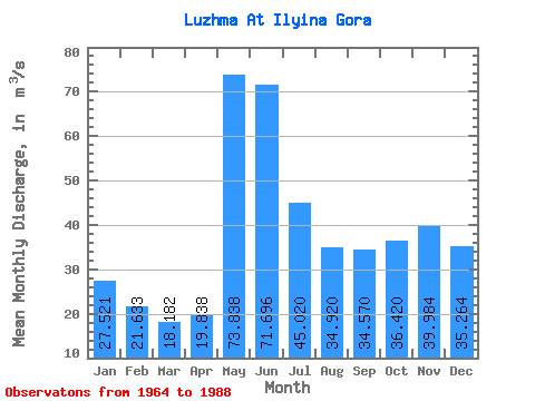
| Statistic | Jan | Feb | Mar | Apr | May | Jun | Jul | Aug | Sep | Oct | Nov | Dec | Annual |
|---|---|---|---|---|---|---|---|---|---|---|---|---|---|
| Mean | 27.52 | 21.63 | 18.18 | 19.84 | 73.84 | 71.70 | 45.02 | 34.92 | 34.57 | 36.42 | 39.98 | 35.26 | 38.55 |
| Standard Deviation | 10.20 | 6.61 | 4.01 | 5.70 | 24.79 | 21.20 | 13.61 | 18.08 | 22.66 | 15.43 | 15.50 | 11.06 | 7.07 |
| Min | 14.80 | 11.90 | 9.66 | 12.20 | 34.30 | 46.50 | 20.70 | 14.00 | 7.84 | 12.50 | 19.70 | 19.20 | 28.18 |
| Max | 64.90 | 43.80 | 30.80 | 36.20 | 128.00 | 139.00 | 74.60 | 96.10 | 119.00 | 70.40 | 81.90 | 59.20 | 53.18 |
| Coefficient of Variation | 0.37 | 0.30 | 0.22 | 0.29 | 0.34 | 0.30 | 0.30 | 0.52 | 0.66 | 0.42 | 0.39 | 0.31 | 0.18 |
 Return to R-Arctic Net Home Page