|
|
|||||||||||||||||
| Point ID: 7300 | Downloads | Plots | Site Data | Other Close Sites | Code: 49076 |
|
|
|||||||||||||||||
| Download | |
|---|---|
| Site Descriptor Information | Site Time Series Data |
| Link to all available data | |
| View: | Time Series | All |
| Units: | mm |
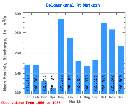
| Statistic | Jan | Feb | Mar | Apr | May | Jun | Jul | Aug | Sep | Oct | Nov | Dec | Annual |
|---|---|---|---|---|---|---|---|---|---|---|---|---|---|
| Mean | 247.97 | 248.36 | 232.09 | 225.18 | 293.58 | 275.15 | 252.42 | 246.97 | 253.12 | 289.85 | 283.24 | 266.91 | 259.57 |
| Standard Deviation | 46.73 | 43.95 | 56.26 | 69.64 | 99.47 | 89.19 | 102.78 | 121.10 | 84.62 | 92.55 | 86.80 | 51.08 | 49.47 |
| Min | 144.00 | 149.00 | 145.00 | 109.00 | 108.00 | 109.00 | 116.00 | 138.00 | 150.00 | 159.00 | 170.00 | 146.00 | 146.67 |
| Max | 373.00 | 380.00 | 411.00 | 437.00 | 453.00 | 538.00 | 720.00 | 686.00 | 525.00 | 509.00 | 556.00 | 365.00 | 430.83 |
| Coefficient of Variation | 0.19 | 0.18 | 0.24 | 0.31 | 0.34 | 0.32 | 0.41 | 0.49 | 0.33 | 0.32 | 0.31 | 0.19 | 0.19 |
| Other Close Sites | ||||||
|---|---|---|---|---|---|---|
| PointID | Latitude | Longitude | Drainage Area | Source | Name | |
| 7301 | "Nyzhny Vig (Soroka) At Vigostrov" | 64.48 | -2314678 | SHI | 11.00 | |
| 7302 | "Nyzhny Vig (Soroka) At Belomorskaya" | 64.52 | -2310273 | SHI | 5.50 | |
 Return to R-Arctic Net Home Page