|
|
|||||||||||||||||
| Point ID: 7290 | Downloads | Plots | Site Data | Code: 49054 |
|
|
|||||||||||||||||
| Download | |
|---|---|
| Site Descriptor Information | Site Time Series Data |
| Link to all available data | |
| View: | Time Series | All |
| Units: | mm |
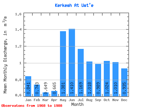
| Statistic | Jan | Feb | Mar | Apr | May | Jun | Jul | Aug | Sep | Oct | Nov | Dec | Annual |
|---|---|---|---|---|---|---|---|---|---|---|---|---|---|
| Mean | 0.84 | 0.74 | 0.65 | 0.67 | 1.38 | 1.41 | 1.17 | 1.02 | 0.99 | 1.02 | 1.01 | 0.94 | 0.99 |
| Standard Deviation | 0.17 | 0.14 | 0.11 | 0.09 | 0.33 | 0.29 | 0.24 | 0.27 | 0.32 | 0.30 | 0.24 | 0.21 | 0.15 |
| Min | 0.55 | 0.45 | 0.47 | 0.53 | 0.95 | 0.92 | 0.70 | 0.57 | 0.52 | 0.64 | 0.59 | 0.50 | 0.73 |
| Max | 1.10 | 0.99 | 0.80 | 0.85 | 2.13 | 1.97 | 1.70 | 1.77 | 1.92 | 1.89 | 1.60 | 1.25 | 1.32 |
| Coefficient of Variation | 0.20 | 0.18 | 0.16 | 0.14 | 0.23 | 0.21 | 0.21 | 0.27 | 0.32 | 0.29 | 0.24 | 0.23 | 0.15 |
 Return to R-Arctic Net Home Page