|
|
|||||||||||||||||
| Point ID: 7289 | Downloads | Plots | Site Data | Code: 49053 |
|
|
|||||||||||||||||
| Download | |
|---|---|
| Site Descriptor Information | Site Time Series Data |
| Link to all available data | |
| View: | Time Series | All |
| Units: | mm |
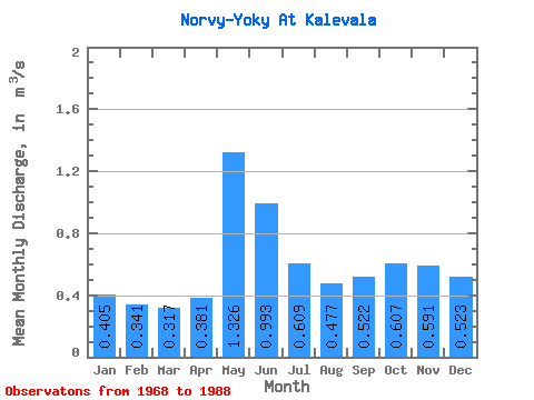
| Statistic | Jan | Feb | Mar | Apr | May | Jun | Jul | Aug | Sep | Oct | Nov | Dec | Annual |
|---|---|---|---|---|---|---|---|---|---|---|---|---|---|
| Mean | 0.41 | 0.34 | 0.32 | 0.38 | 1.33 | 0.99 | 0.61 | 0.48 | 0.52 | 0.61 | 0.59 | 0.52 | 0.59 |
| Standard Deviation | 0.10 | 0.10 | 0.08 | 0.11 | 0.36 | 0.21 | 0.20 | 0.20 | 0.20 | 0.18 | 0.21 | 0.15 | 0.11 |
| Min | 0.23 | 0.20 | 0.16 | 0.18 | 0.74 | 0.68 | 0.28 | 0.21 | 0.21 | 0.30 | 0.31 | 0.30 | 0.40 |
| Max | 0.57 | 0.63 | 0.44 | 0.67 | 2.05 | 1.38 | 1.08 | 1.05 | 1.02 | 0.89 | 1.19 | 0.90 | 0.75 |
| Coefficient of Variation | 0.24 | 0.30 | 0.25 | 0.30 | 0.27 | 0.22 | 0.33 | 0.42 | 0.39 | 0.29 | 0.36 | 0.29 | 0.18 |
 Return to R-Arctic Net Home Page