|
|
|||||||||||||||||
| Point ID: 7278 | Downloads | Plots | Site Data | Code: 49033 |
|
|
|||||||||||||||||
| Download | |
|---|---|
| Site Descriptor Information | Site Time Series Data |
| Link to all available data | |
| View: | Time Series | All |
| Units: | mm |
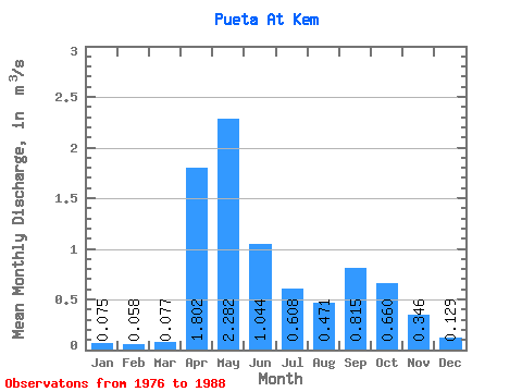
| Statistic | Jan | Feb | Mar | Apr | May | Jun | Jul | Aug | Sep | Oct | Nov | Dec | Annual |
|---|---|---|---|---|---|---|---|---|---|---|---|---|---|
| Mean | 0.07 | 0.06 | 0.08 | 1.80 | 2.28 | 1.04 | 0.61 | 0.47 | 0.81 | 0.66 | 0.35 | 0.13 | 0.70 |
| Standard Deviation | 0.05 | 0.02 | 0.02 | 1.38 | 1.48 | 1.48 | 1.10 | 0.65 | 0.95 | 0.49 | 0.24 | 0.07 | 0.40 |
| Min | 0.02 | 0.03 | 0.05 | 0.07 | 0.37 | 0.11 | 0.04 | 0.05 | 0.05 | 0.07 | 0.06 | 0.04 | 0.39 |
| Max | 0.23 | 0.10 | 0.13 | 4.44 | 5.39 | 5.46 | 3.91 | 2.48 | 3.58 | 1.77 | 0.75 | 0.31 | 1.94 |
| Coefficient of Variation | 0.70 | 0.35 | 0.30 | 0.76 | 0.65 | 1.41 | 1.81 | 1.38 | 1.17 | 0.74 | 0.68 | 0.58 | 0.57 |
 Return to R-Arctic Net Home Page