|
|
|||||||||||||||||
| Point ID: 7266 | Downloads | Plots | Site Data | Code: 49008 |
|
|
|||||||||||||||||
| Download | |
|---|---|
| Site Descriptor Information | Site Time Series Data |
| Link to all available data | |
| View: | Time Series | All |
| Units: | mm |
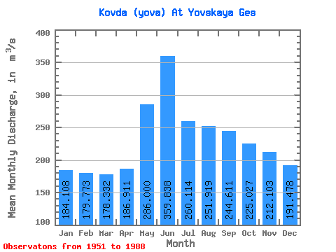
| Statistic | Jan | Feb | Mar | Apr | May | Jun | Jul | Aug | Sep | Oct | Nov | Dec | Annual |
|---|---|---|---|---|---|---|---|---|---|---|---|---|---|
| Mean | 184.11 | 179.77 | 178.33 | 186.91 | 286.00 | 359.84 | 260.11 | 251.92 | 244.61 | 225.03 | 212.10 | 191.48 | 231.27 |
| Standard Deviation | 68.04 | 74.12 | 75.09 | 89.42 | 115.40 | 183.52 | 91.75 | 62.61 | 67.42 | 71.65 | 59.02 | 54.53 | 42.73 |
| Min | 39.00 | 57.50 | 66.70 | 62.10 | 115.00 | 121.00 | 41.20 | 111.00 | 61.60 | 52.00 | 98.80 | 88.70 | 162.90 |
| Max | 298.00 | 293.00 | 302.00 | 412.00 | 644.00 | 846.00 | 443.00 | 361.00 | 374.00 | 394.00 | 327.00 | 286.00 | 368.42 |
| Coefficient of Variation | 0.37 | 0.41 | 0.42 | 0.48 | 0.40 | 0.51 | 0.35 | 0.25 | 0.28 | 0.32 | 0.28 | 0.28 | 0.18 |
 Return to R-Arctic Net Home Page