|
|
|||||||||||||||||
| Point ID: 7262 | Downloads | Plots | Site Data | Code: 12614 |
|
|
|||||||||||||||||
| Download | |
|---|---|
| Site Descriptor Information | Site Time Series Data |
| Link to all available data | |
| View: | Time Series | All |
| Units: | mm |
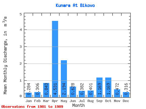
| Statistic | Jan | Feb | Mar | Apr | May | Jun | Jul | Aug | Sep | Oct | Nov | Dec | Annual |
|---|---|---|---|---|---|---|---|---|---|---|---|---|---|
| Mean | 0.28 | 0.31 | 0.84 | 4.53 | 2.19 | 0.63 | 0.38 | 0.40 | 1.17 | 1.17 | 0.47 | 0.32 | 1.06 |
| Standard Deviation | 0.11 | 0.19 | 1.06 | 2.71 | 1.56 | 0.37 | 0.26 | 0.29 | 1.75 | 1.04 | 0.28 | 0.15 | 0.54 |
| Min | 0.14 | 0.18 | 0.20 | 1.62 | 0.46 | 0.15 | 0.14 | 0.24 | 0.27 | 0.26 | 0.13 | 0.16 | 0.49 |
| Max | 0.51 | 0.76 | 3.21 | 8.18 | 5.68 | 1.31 | 0.87 | 1.16 | 5.78 | 3.14 | 0.86 | 0.57 | 2.15 |
| Coefficient of Variation | 0.40 | 0.61 | 1.26 | 0.60 | 0.71 | 0.59 | 0.68 | 0.72 | 1.50 | 0.89 | 0.58 | 0.47 | 0.51 |
 Return to R-Arctic Net Home Page