|
|
|||||||||||||||||
| Point ID: 7258 | Downloads | Plots | Site Data | Code: 12608 |
|
|
|||||||||||||||||
| Download | |
|---|---|
| Site Descriptor Information | Site Time Series Data |
| Link to all available data | |
| View: | Time Series | All |
| Units: | mm |
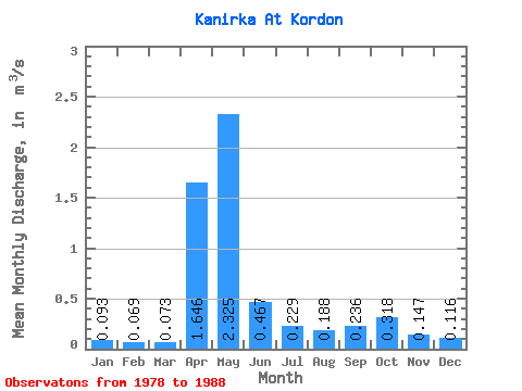
| Statistic | Jan | Feb | Mar | Apr | May | Jun | Jul | Aug | Sep | Oct | Nov | Dec | Annual |
|---|---|---|---|---|---|---|---|---|---|---|---|---|---|
| Mean | 0.09 | 0.07 | 0.07 | 1.65 | 2.33 | 0.47 | 0.23 | 0.19 | 0.24 | 0.32 | 0.15 | 0.12 | 0.52 |
| Standard Deviation | 0.03 | 0.02 | 0.03 | 1.34 | 2.93 | 0.22 | 0.12 | 0.10 | 0.13 | 0.19 | 0.05 | 0.04 | 0.43 |
| Min | 0.05 | 0.05 | 0.05 | 0.55 | 0.25 | 0.22 | 0.10 | 0.09 | 0.13 | 0.12 | 0.07 | 0.08 | 0.22 |
| Max | 0.14 | 0.12 | 0.14 | 3.54 | 4.40 | 0.64 | 0.43 | 0.40 | 0.54 | 0.60 | 0.22 | 0.19 | 0.82 |
| Coefficient of Variation | 0.32 | 0.34 | 0.39 | 0.81 | 1.26 | 0.47 | 0.53 | 0.54 | 0.55 | 0.61 | 0.34 | 0.32 | 0.82 |
 Return to R-Arctic Net Home Page