|
|
|||||||||||||||||
| Point ID: 7246 | Downloads | Plots | Site Data | Code: 12517 |
|
|
|||||||||||||||||
| Download | |
|---|---|
| Site Descriptor Information | Site Time Series Data |
| Link to all available data | |
| View: | Time Series | All |
| Units: | mm |
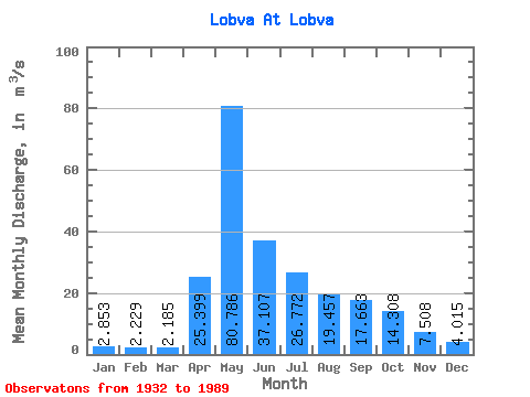
| Statistic | Jan | Feb | Mar | Apr | May | Jun | Jul | Aug | Sep | Oct | Nov | Dec | Annual |
|---|---|---|---|---|---|---|---|---|---|---|---|---|---|
| Mean | 2.85 | 2.23 | 2.19 | 25.40 | 80.79 | 37.11 | 26.77 | 19.46 | 17.66 | 14.31 | 7.51 | 4.01 | 20.10 |
| Standard Deviation | 1.60 | 1.18 | 1.02 | 18.25 | 37.89 | 22.25 | 26.66 | 17.44 | 17.30 | 9.69 | 4.01 | 1.98 | 6.83 |
| Min | 0.37 | 0.25 | 0.39 | 2.39 | 16.40 | 10.80 | 4.34 | 3.91 | 3.43 | 3.06 | 2.40 | 0.97 | 9.28 |
| Max | 10.20 | 5.93 | 5.51 | 76.40 | 167.00 | 99.20 | 144.00 | 67.30 | 95.00 | 45.50 | 22.00 | 12.40 | 40.49 |
| Coefficient of Variation | 0.56 | 0.53 | 0.47 | 0.72 | 0.47 | 0.60 | 1.00 | 0.90 | 0.98 | 0.68 | 0.53 | 0.49 | 0.34 |
 Return to R-Arctic Net Home Page