|
|
|||||||||||||||||
| Point ID: 7240 | Downloads | Plots | Site Data | Code: 12430 |
|
|
|||||||||||||||||
| Download | |
|---|---|
| Site Descriptor Information | Site Time Series Data |
| Link to all available data | |
| View: | Time Series | All |
| Units: | mm |
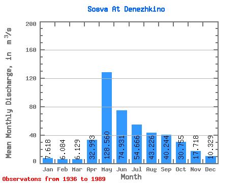
| Statistic | Jan | Feb | Mar | Apr | May | Jun | Jul | Aug | Sep | Oct | Nov | Dec | Annual |
|---|---|---|---|---|---|---|---|---|---|---|---|---|---|
| Mean | 7.62 | 6.08 | 6.13 | 32.99 | 128.56 | 74.93 | 54.67 | 43.23 | 40.24 | 30.75 | 17.72 | 10.33 | 38.11 |
| Standard Deviation | 3.07 | 2.37 | 2.10 | 25.11 | 58.37 | 37.16 | 42.41 | 33.15 | 33.19 | 17.00 | 9.10 | 4.17 | 12.07 |
| Min | 1.85 | 1.92 | 2.05 | 4.88 | 42.70 | 26.00 | 14.60 | 10.50 | 9.72 | 8.00 | 3.68 | 2.88 | 17.47 |
| Max | 19.10 | 14.70 | 14.40 | 101.00 | 338.00 | 182.00 | 209.00 | 165.00 | 194.00 | 82.30 | 41.40 | 23.40 | 75.18 |
| Coefficient of Variation | 0.40 | 0.39 | 0.34 | 0.76 | 0.45 | 0.50 | 0.78 | 0.77 | 0.82 | 0.55 | 0.51 | 0.40 | 0.32 |
 Return to R-Arctic Net Home Page