|
|
|||||||||||||||||
| Point ID: 7237 | Downloads | Plots | Site Data | Code: 12417 |
|
|
|||||||||||||||||
| Download | |
|---|---|
| Site Descriptor Information | Site Time Series Data |
| Link to all available data | |
| View: | Time Series | All |
| Units: | mm |
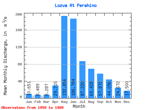
| Statistic | Jan | Feb | Mar | Apr | May | Jun | Jul | Aug | Sep | Oct | Nov | Dec | Annual |
|---|---|---|---|---|---|---|---|---|---|---|---|---|---|
| Mean | 10.65 | 8.49 | 8.29 | 29.71 | 192.86 | 186.78 | 87.22 | 69.43 | 57.87 | 44.10 | 24.67 | 17.50 | 61.95 |
| Standard Deviation | 3.09 | 2.45 | 2.64 | 25.53 | 62.94 | 87.84 | 50.27 | 42.86 | 26.19 | 21.75 | 10.25 | 7.26 | 13.35 |
| Min | 5.20 | 4.34 | 4.01 | 8.67 | 92.00 | 58.80 | 17.70 | 18.50 | 20.10 | 16.40 | 7.49 | 6.71 | 47.37 |
| Max | 18.50 | 15.00 | 16.20 | 120.00 | 334.00 | 374.00 | 223.00 | 196.00 | 120.00 | 94.10 | 53.40 | 38.20 | 90.56 |
| Coefficient of Variation | 0.29 | 0.29 | 0.32 | 0.86 | 0.33 | 0.47 | 0.58 | 0.62 | 0.45 | 0.49 | 0.41 | 0.41 | 0.22 |
 Return to R-Arctic Net Home Page