|
|
|||||||||||||||||
| Point ID: 7221 | Downloads | Plots | Site Data | Code: 12320 |
|
|
|||||||||||||||||
| Download | |
|---|---|
| Site Descriptor Information | Site Time Series Data |
| Link to all available data | |
| View: | Time Series | All |
| Units: | mm |
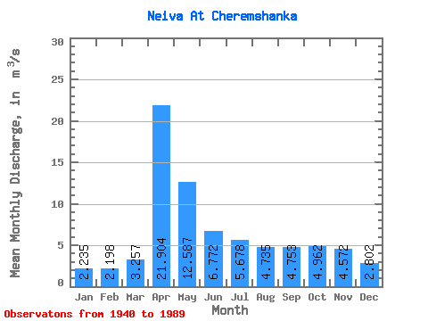
| Statistic | Jan | Feb | Mar | Apr | May | Jun | Jul | Aug | Sep | Oct | Nov | Dec | Annual |
|---|---|---|---|---|---|---|---|---|---|---|---|---|---|
| Mean | 2.23 | 2.20 | 3.26 | 21.90 | 12.59 | 6.77 | 5.68 | 4.74 | 4.75 | 4.96 | 4.57 | 2.80 | 6.46 |
| Standard Deviation | 1.50 | 1.76 | 2.19 | 12.97 | 8.68 | 3.94 | 3.64 | 5.94 | 4.74 | 4.32 | 3.59 | 2.13 | 2.95 |
| Min | 0.21 | 0.00 | 0.01 | 4.13 | 2.91 | 1.67 | 0.97 | 0.79 | 1.02 | 0.67 | 0.52 | 0.39 | 2.63 |
| Max | 7.64 | 10.60 | 12.90 | 59.40 | 36.70 | 16.80 | 16.80 | 42.00 | 29.50 | 18.00 | 17.40 | 12.30 | 16.51 |
| Coefficient of Variation | 0.67 | 0.80 | 0.67 | 0.59 | 0.69 | 0.58 | 0.64 | 1.25 | 1.00 | 0.87 | 0.79 | 0.76 | 0.46 |
 Return to R-Arctic Net Home Page