|
|
|||||||||||||||||
| Point ID: 7212 | Downloads | Plots | Site Data | Code: 12244 |
|
|
|||||||||||||||||
| Download | |
|---|---|
| Site Descriptor Information | Site Time Series Data |
| Link to all available data | |
| View: | Time Series | All |
| Units: | mm |
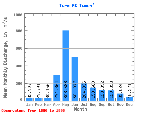
| Statistic | Jan | Feb | Mar | Apr | May | Jun | Jul | Aug | Sep | Oct | Nov | Dec | Annual |
|---|---|---|---|---|---|---|---|---|---|---|---|---|---|
| Mean | 32.91 | 29.79 | 30.16 | 291.36 | 803.59 | 504.07 | 204.94 | 153.66 | 128.89 | 120.83 | 83.82 | 48.37 | 202.70 |
| Standard Deviation | 16.88 | 12.37 | 11.16 | 201.37 | 461.40 | 701.83 | 165.06 | 161.96 | 138.70 | 123.48 | 73.72 | 33.45 | 110.19 |
| Min | 11.30 | 11.10 | 12.70 | 25.50 | 137.00 | 53.80 | 31.60 | 22.40 | 21.30 | 21.50 | 13.80 | 13.70 | 43.16 |
| Max | 105.00 | 79.20 | 71.60 | 1030.00 | 2570.00 | 6810.00 | 973.00 | 767.00 | 742.00 | 658.00 | 532.00 | 224.00 | 796.73 |
| Coefficient of Variation | 0.51 | 0.41 | 0.37 | 0.69 | 0.57 | 1.39 | 0.81 | 1.05 | 1.08 | 1.02 | 0.88 | 0.69 | 0.54 |
 Return to R-Arctic Net Home Page