|
|
|||||||||||||||||
| Point ID: 7208 | Downloads | Plots | Site Data | Code: 12225 |
|
|
|||||||||||||||||
| Download | |
|---|---|
| Site Descriptor Information | Site Time Series Data |
| Link to all available data | |
| View: | Time Series | All |
| Units: | mm |
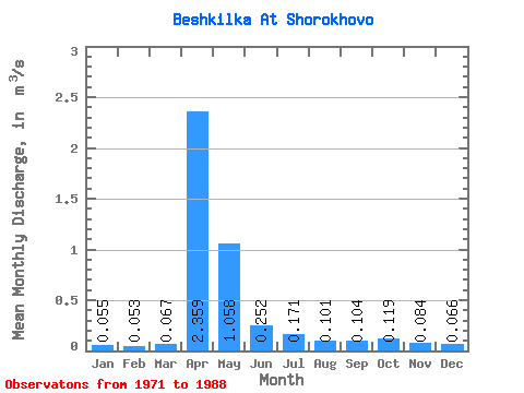
| Statistic | Jan | Feb | Mar | Apr | May | Jun | Jul | Aug | Sep | Oct | Nov | Dec | Annual |
|---|---|---|---|---|---|---|---|---|---|---|---|---|---|
| Mean | 0.06 | 0.05 | 0.07 | 2.36 | 1.06 | 0.25 | 0.17 | 0.10 | 0.10 | 0.12 | 0.08 | 0.07 | 0.41 |
| Standard Deviation | 0.02 | 0.02 | 0.04 | 2.24 | 1.06 | 0.24 | 0.28 | 0.13 | 0.08 | 0.07 | 0.06 | 0.04 | 0.28 |
| Min | 0.02 | 0.02 | 0.03 | 0.33 | 0.20 | 0.05 | 0.03 | 0.02 | 0.02 | 0.03 | 0.03 | 0.03 | 0.11 |
| Max | 0.10 | 0.08 | 0.18 | 7.14 | 3.35 | 0.79 | 1.23 | 0.57 | 0.29 | 0.29 | 0.27 | 0.19 | 0.87 |
| Coefficient of Variation | 0.35 | 0.35 | 0.58 | 0.95 | 1.00 | 0.97 | 1.65 | 1.28 | 0.77 | 0.62 | 0.76 | 0.61 | 0.70 |
 Return to R-Arctic Net Home Page