|
|
|||||||||||||||||
| Point ID: 7197 | Downloads | Plots | Site Data | Code: 12189 |
|
|
|||||||||||||||||
| Download | |
|---|---|
| Site Descriptor Information | Site Time Series Data |
| Link to all available data | |
| View: | Time Series | All |
| Units: | mm |
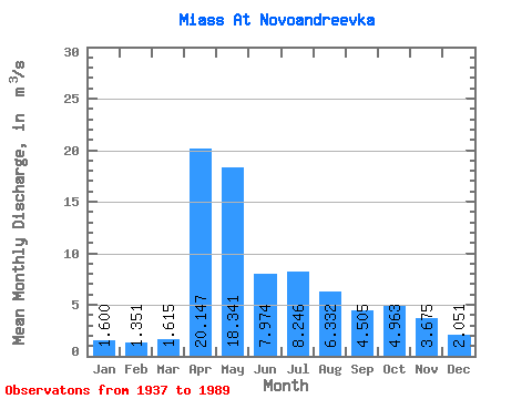
| Statistic | Jan | Feb | Mar | Apr | May | Jun | Jul | Aug | Sep | Oct | Nov | Dec | Annual |
|---|---|---|---|---|---|---|---|---|---|---|---|---|---|
| Mean | 1.60 | 1.35 | 1.61 | 20.15 | 18.34 | 7.97 | 8.25 | 6.33 | 4.50 | 4.96 | 3.67 | 2.05 | 6.82 |
| Standard Deviation | 0.88 | 0.80 | 0.95 | 13.48 | 13.56 | 5.29 | 8.73 | 7.97 | 3.56 | 4.17 | 2.96 | 1.01 | 2.94 |
| Min | 0.27 | 0.07 | 0.17 | 4.43 | 3.58 | 1.25 | 1.05 | 0.85 | 0.95 | 0.88 | 0.40 | 0.35 | 1.94 |
| Max | 3.39 | 3.35 | 4.24 | 61.50 | 83.20 | 25.10 | 42.60 | 50.20 | 15.00 | 20.40 | 17.60 | 4.20 | 15.48 |
| Coefficient of Variation | 0.55 | 0.59 | 0.59 | 0.67 | 0.74 | 0.66 | 1.06 | 1.26 | 0.79 | 0.84 | 0.81 | 0.49 | 0.43 |
 Return to R-Arctic Net Home Page