|
|
|||||||||||||||||
| Point ID: 7195 | Downloads | Plots | Site Data | Code: 12166 |
|
|
|||||||||||||||||
| Download | |
|---|---|
| Site Descriptor Information | Site Time Series Data |
| Link to all available data | |
| View: | Time Series | All |
| Units: | mm |
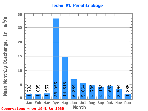
| Statistic | Jan | Feb | Mar | Apr | May | Jun | Jul | Aug | Sep | Oct | Nov | Dec | Annual |
|---|---|---|---|---|---|---|---|---|---|---|---|---|---|
| Mean | 1.78 | 1.83 | 1.96 | 28.09 | 14.52 | 6.88 | 5.66 | 4.79 | 4.19 | 4.69 | 3.59 | 1.89 | 6.66 |
| Standard Deviation | 1.70 | 2.13 | 2.20 | 26.62 | 15.96 | 7.58 | 8.43 | 5.29 | 4.20 | 6.04 | 5.78 | 1.78 | 6.13 |
| Min | 0.29 | 0.23 | 0.25 | 2.71 | 1.33 | 0.57 | 0.47 | 0.39 | 0.36 | 0.33 | 0.43 | 0.31 | 0.66 |
| Max | 5.92 | 10.20 | 10.10 | 103.00 | 79.30 | 37.00 | 46.50 | 24.70 | 17.20 | 31.50 | 30.30 | 6.42 | 25.04 |
| Coefficient of Variation | 0.95 | 1.16 | 1.13 | 0.95 | 1.10 | 1.10 | 1.49 | 1.10 | 1.00 | 1.29 | 1.61 | 0.95 | 0.92 |
 Return to R-Arctic Net Home Page