|
|
|||||||||||||||||
| Point ID: 7169 | Downloads | Plots | Site Data | Code: 12071 |
|
|
|||||||||||||||||
| Download | |
|---|---|
| Site Descriptor Information | Site Time Series Data |
| Link to all available data | |
| View: | Time Series | All |
| Units: | mm |
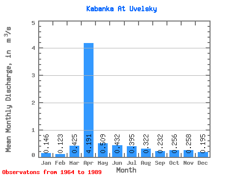
| Statistic | Jan | Feb | Mar | Apr | May | Jun | Jul | Aug | Sep | Oct | Nov | Dec | Annual |
|---|---|---|---|---|---|---|---|---|---|---|---|---|---|
| Mean | 0.15 | 0.12 | 0.42 | 4.19 | 0.51 | 0.43 | 0.40 | 0.32 | 0.23 | 0.26 | 0.26 | 0.20 | 0.65 |
| Standard Deviation | 0.10 | 0.08 | 1.08 | 4.85 | 0.43 | 0.52 | 0.47 | 0.44 | 0.15 | 0.13 | 0.12 | 0.10 | 0.51 |
| Min | 0.01 | 0.02 | 0.00 | 0.29 | 0.08 | 0.04 | 0.01 | 0.01 | 0.01 | 0.03 | 0.04 | 0.04 | 0.08 |
| Max | 0.45 | 0.28 | 5.58 | 16.40 | 2.26 | 2.56 | 1.90 | 2.36 | 0.70 | 0.53 | 0.50 | 0.40 | 1.57 |
| Coefficient of Variation | 0.68 | 0.63 | 2.54 | 1.16 | 0.85 | 1.20 | 1.19 | 1.37 | 0.65 | 0.50 | 0.46 | 0.53 | 0.78 |
 Return to R-Arctic Net Home Page