|
|
|||||||||||||||||
| Point ID: 7154 | Downloads | Plots | Site Data | Code: 12018 |
|
|
|||||||||||||||||
| Download | |
|---|---|
| Site Descriptor Information | Site Time Series Data |
| Link to all available data | |
| View: | Time Series | All |
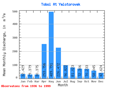
| Units: | mm |
| Statistic | Jan | Feb | Mar | Apr | May | Jun | Jul | Aug | Sep | Oct | Nov | Dec | Annual |
|---|---|---|---|---|---|---|---|---|---|---|---|---|---|
| Mean | 32.43 | 29.38 | 30.38 | 253.76 | 489.79 | 226.47 | 96.82 | 81.02 | 72.31 | 70.23 | 58.05 | 42.62 | 123.61 |
| Standard Deviation | 17.62 | 15.82 | 15.85 | 220.15 | 375.40 | 195.86 | 79.83 | 64.06 | 57.42 | 52.16 | 37.63 | 25.21 | 75.37 |
| Min | 7.20 | 5.21 | 5.42 | 26.20 | 72.20 | 24.10 | 14.70 | 11.70 | 12.60 | 16.30 | 11.60 | 7.94 | 30.09 |
| Max | 105.00 | 99.50 | 107.00 | 1500.00 | 1720.00 | 936.00 | 435.00 | 354.00 | 355.00 | 291.00 | 193.00 | 123.00 | 345.38 |
| Coefficient of Variation | 0.54 | 0.54 | 0.52 | 0.87 | 0.77 | 0.86 | 0.82 | 0.79 | 0.79 | 0.74 | 0.65 | 0.59 | 0.61 |
 Return to R-Arctic Net Home Page