|
|
|||||||||||||||||
| Point ID: 715 | Downloads | Plots | Site Data | Code: 07DA016 |
|
|
|||||||||||||||||
| Download | |
|---|---|
| Site Descriptor Information | Site Time Series Data |
| Link to all available data | |
| View: | Time Series | All |
| Units: | mm |
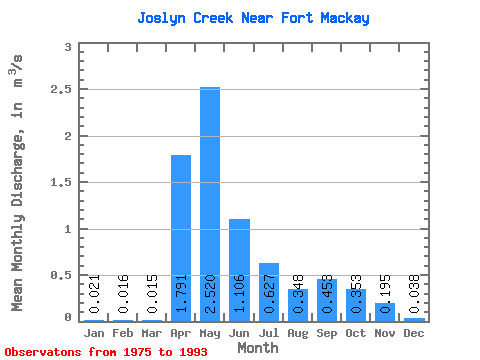
| Statistic | Jan | Feb | Mar | Apr | May | Jun | Jul | Aug | Sep | Oct | Nov | Dec | Annual |
|---|---|---|---|---|---|---|---|---|---|---|---|---|---|
| Mean | 0.02 | 0.02 | 0.01 | 1.79 | 2.52 | 1.11 | 0.63 | 0.35 | 0.45 | 0.35 | 0.20 | 0.04 | 0.56 |
| Standard Deviation | 0.02 | 0.01 | 0.01 | 1.87 | 2.26 | 1.00 | 0.74 | 0.30 | 0.70 | 0.24 | 0.10 | 0.03 | 0.35 |
| Min | 0.00 | 0.00 | 0.00 | 0.52 | 0.25 | 0.17 | 0.06 | 0.04 | 0.00 | 0.09 | 0.08 | 0.00 | 0.26 |
| Max | 0.04 | 0.04 | 0.05 | 8.00 | 7.19 | 3.42 | 3.19 | 1.22 | 3.02 | 1.01 | 0.33 | 0.09 | 0.92 |
| Coefficient of Variation | 0.78 | 0.89 | 0.93 | 1.04 | 0.90 | 0.90 | 1.17 | 0.87 | 1.55 | 0.67 | 0.50 | 0.87 | 0.63 |
 Return to R-Arctic Net Home Page