|
|
|||||||||||||||||
| Point ID: 7143 | Downloads | Plots | Site Data | Code: 11805 |
|
|
|||||||||||||||||
| Download | |
|---|---|
| Site Descriptor Information | Site Time Series Data |
| Link to all available data | |
| View: | Time Series | All |
| Units: | mm |
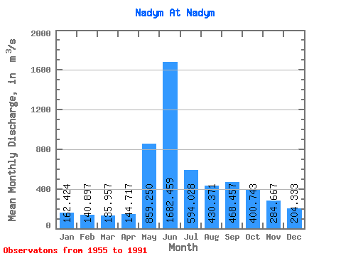
| Statistic | Jan | Feb | Mar | Apr | May | Jun | Jul | Aug | Sep | Oct | Nov | Dec | Annual |
|---|---|---|---|---|---|---|---|---|---|---|---|---|---|
| Mean | 162.42 | 140.90 | 135.96 | 144.72 | 859.25 | 1682.46 | 594.03 | 430.37 | 468.46 | 400.74 | 284.67 | 204.33 | 458.47 |
| Standard Deviation | 33.62 | 27.01 | 22.82 | 29.45 | 619.56 | 742.00 | 184.35 | 160.57 | 135.35 | 138.26 | 97.28 | 51.68 | 82.78 |
| Min | 77.80 | 70.40 | 72.10 | 90.80 | 153.00 | 637.00 | 303.00 | 214.00 | 219.00 | 177.00 | 153.00 | 106.00 | 335.37 |
| Max | 218.00 | 179.00 | 171.00 | 230.00 | 2110.00 | 3100.00 | 1090.00 | 971.00 | 819.00 | 795.00 | 667.00 | 334.00 | 664.25 |
| Coefficient of Variation | 0.21 | 0.19 | 0.17 | 0.20 | 0.72 | 0.44 | 0.31 | 0.37 | 0.29 | 0.34 | 0.34 | 0.25 | 0.18 |
 Return to R-Arctic Net Home Page