|
|
|||||||||||||||||
| Point ID: 7134 | Downloads | Plots | Site Data | Code: 11619 |
|
|
|||||||||||||||||
| Download | |
|---|---|
| Site Descriptor Information | Site Time Series Data |
| Link to all available data | |
| View: | Time Series | All |
| Units: | mm |
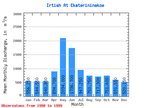
| Statistic | Jan | Feb | Mar | Apr | May | Jun | Jul | Aug | Sep | Oct | Nov | Dec | Annual |
|---|---|---|---|---|---|---|---|---|---|---|---|---|---|
| Mean | 556.25 | 544.55 | 540.85 | 894.70 | 2094.00 | 1736.70 | 947.25 | 750.75 | 717.30 | 751.60 | 591.55 | 520.15 | 887.14 |
| Standard Deviation | 120.30 | 129.92 | 138.80 | 362.25 | 361.60 | 464.55 | 249.15 | 174.68 | 161.12 | 158.34 | 137.76 | 127.64 | 158.77 |
| Min | 351.00 | 342.00 | 288.00 | 484.00 | 1290.00 | 844.00 | 523.00 | 440.00 | 403.00 | 447.00 | 330.00 | 315.00 | 597.83 |
| Max | 776.00 | 802.00 | 821.00 | 1780.00 | 2670.00 | 2430.00 | 1490.00 | 1040.00 | 997.00 | 1040.00 | 933.00 | 811.00 | 1186.17 |
| Coefficient of Variation | 0.22 | 0.24 | 0.26 | 0.41 | 0.17 | 0.27 | 0.26 | 0.23 | 0.23 | 0.21 | 0.23 | 0.24 | 0.18 |
 Return to R-Arctic Net Home Page