|
|
|||||||||||||||||
| Point ID: 7125 | Downloads | Plots | Site Data | Code: 11589 |
|
|
|||||||||||||||||
| Download | |
|---|---|
| Site Descriptor Information | Site Time Series Data |
| Link to all available data | |
| View: | Time Series | All |
| Units: | mm |
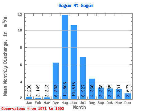
| Statistic | Jan | Feb | Mar | Apr | May | Jun | Jul | Aug | Sep | Oct | Nov | Dec | Annual |
|---|---|---|---|---|---|---|---|---|---|---|---|---|---|
| Mean | 2.28 | 2.15 | 2.21 | 6.23 | 11.80 | 10.62 | 6.93 | 4.37 | 3.36 | 3.23 | 3.20 | 2.68 | 4.92 |
| Standard Deviation | 1.44 | 1.36 | 1.26 | 9.79 | 10.16 | 8.40 | 5.13 | 2.75 | 2.21 | 2.43 | 2.48 | 1.65 | 2.79 |
| Min | 0.48 | 0.35 | 0.51 | 0.79 | 1.54 | 2.67 | 1.79 | 0.97 | 0.86 | 0.61 | 0.79 | 0.53 | 1.39 |
| Max | 5.64 | 5.00 | 4.76 | 44.50 | 34.20 | 32.70 | 21.50 | 11.20 | 9.11 | 11.00 | 11.80 | 7.20 | 11.40 |
| Coefficient of Variation | 0.63 | 0.63 | 0.57 | 1.57 | 0.86 | 0.79 | 0.74 | 0.63 | 0.66 | 0.75 | 0.78 | 0.61 | 0.57 |
 Return to R-Arctic Net Home Page