|
|
|||||||||||||||||
| Point ID: 7123 | Downloads | Plots | Site Data | Code: 11587 |
|
|
|||||||||||||||||
| Download | |
|---|---|
| Site Descriptor Information | Site Time Series Data |
| Link to all available data | |
| View: | Time Series | All |
| Units: | mm |
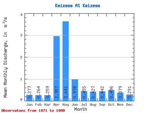
| Statistic | Jan | Feb | Mar | Apr | May | Jun | Jul | Aug | Sep | Oct | Nov | Dec | Annual |
|---|---|---|---|---|---|---|---|---|---|---|---|---|---|
| Mean | 0.28 | 0.26 | 0.26 | 2.96 | 3.64 | 0.98 | 0.46 | 0.43 | 0.44 | 0.50 | 0.38 | 0.29 | 0.95 |
| Standard Deviation | 0.07 | 0.08 | 0.08 | 2.82 | 2.67 | 0.56 | 0.33 | 0.23 | 0.26 | 0.24 | 0.13 | 0.07 | 0.39 |
| Min | 0.19 | 0.15 | 0.16 | 0.54 | 0.56 | 0.07 | 0.01 | 0.03 | 0.20 | 0.28 | 0.24 | 0.22 | 0.37 |
| Max | 0.41 | 0.40 | 0.43 | 10.50 | 9.01 | 2.06 | 1.51 | 0.78 | 1.02 | 1.12 | 0.60 | 0.47 | 1.46 |
| Coefficient of Variation | 0.26 | 0.31 | 0.30 | 0.95 | 0.73 | 0.57 | 0.73 | 0.53 | 0.60 | 0.49 | 0.33 | 0.22 | 0.41 |
 Return to R-Arctic Net Home Page