|
|
|||||||||||||||||
| Point ID: 7120 | Downloads | Plots | Site Data | Code: 11577 |
|
|
|||||||||||||||||
| Download | |
|---|---|
| Site Descriptor Information | Site Time Series Data |
| Link to all available data | |
| View: | Time Series | All |
| Units: | mm |
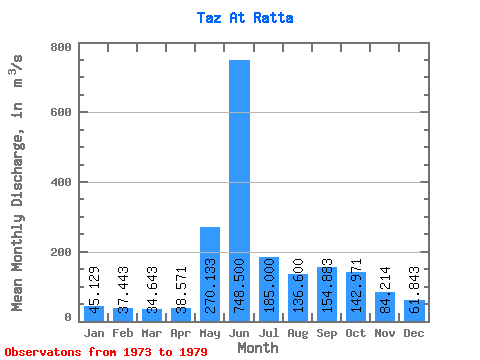
| Statistic | Jan | Feb | Mar | Apr | May | Jun | Jul | Aug | Sep | Oct | Nov | Dec | Annual |
|---|---|---|---|---|---|---|---|---|---|---|---|---|---|
| Mean | 45.13 | 37.44 | 34.64 | 38.57 | 270.13 | 748.50 | 185.00 | 136.60 | 154.88 | 142.97 | 84.21 | 61.84 | 162.10 |
| Standard Deviation | 4.93 | 5.30 | 5.32 | 4.58 | 155.70 | 226.29 | 40.91 | 46.16 | 60.56 | 47.86 | 25.64 | 14.59 | 11.94 |
| Min | 37.60 | 31.80 | 28.90 | 32.50 | 75.80 | 351.00 | 132.00 | 103.00 | 74.80 | 65.80 | 43.50 | 43.70 | 143.13 |
| Max | 51.40 | 45.00 | 43.80 | 44.60 | 529.00 | 948.00 | 229.00 | 211.00 | 232.00 | 191.00 | 121.00 | 88.00 | 172.53 |
| Coefficient of Variation | 0.11 | 0.14 | 0.15 | 0.12 | 0.58 | 0.30 | 0.22 | 0.34 | 0.39 | 0.34 | 0.30 | 0.24 | 0.07 |
 Return to R-Arctic Net Home Page