|
|
|||||||||||||||||
| Point ID: 7117 | Downloads | Plots | Site Data | Code: 11573 |
|
|
|||||||||||||||||
| Download | |
|---|---|
| Site Descriptor Information | Site Time Series Data |
| Link to all available data | |
| View: | Time Series | All |
| Units: | mm |
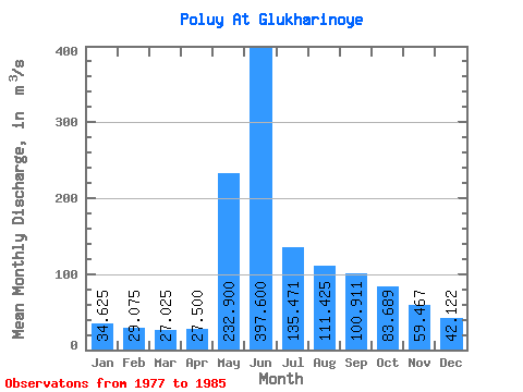
| Statistic | Jan | Feb | Mar | Apr | May | Jun | Jul | Aug | Sep | Oct | Nov | Dec | Annual |
|---|---|---|---|---|---|---|---|---|---|---|---|---|---|
| Mean | 34.62 | 29.07 | 27.02 | 27.50 | 232.90 | 397.60 | 135.47 | 111.42 | 100.91 | 83.69 | 59.47 | 42.12 | 116.11 |
| Standard Deviation | 6.92 | 4.86 | 3.50 | 4.26 | 228.28 | 243.77 | 64.89 | 79.46 | 40.38 | 21.18 | 11.14 | 6.70 | 40.00 |
| Min | 26.60 | 21.90 | 20.60 | 20.10 | 27.30 | 131.00 | 77.70 | 56.50 | 61.50 | 60.20 | 44.00 | 30.00 | 79.27 |
| Max | 47.10 | 36.80 | 32.70 | 33.30 | 582.00 | 717.00 | 258.00 | 297.00 | 195.00 | 119.00 | 72.40 | 52.00 | 171.66 |
| Coefficient of Variation | 0.20 | 0.17 | 0.13 | 0.15 | 0.98 | 0.61 | 0.48 | 0.71 | 0.40 | 0.25 | 0.19 | 0.16 | 0.34 |
 Return to R-Arctic Net Home Page