|
|
|||||||||||||||||
| Point ID: 7107 | Downloads | Plots | Site Data | Code: 11549 |
|
|
|||||||||||||||||
| Download | |
|---|---|
| Site Descriptor Information | Site Time Series Data |
| Link to all available data | |
| View: | Time Series | All |
| Units: | mm |
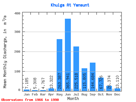
| Statistic | Jan | Feb | Mar | Apr | May | Jun | Jul | Aug | Sep | Oct | Nov | Dec | Annual |
|---|---|---|---|---|---|---|---|---|---|---|---|---|---|
| Mean | 7.18 | 5.31 | 4.77 | 13.32 | 263.39 | 365.94 | 225.52 | 115.81 | 144.68 | 67.73 | 26.37 | 13.11 | 103.90 |
| Standard Deviation | 2.46 | 2.40 | 2.21 | 19.88 | 135.86 | 155.92 | 109.06 | 56.87 | 82.39 | 27.33 | 8.03 | 4.24 | 19.57 |
| Min | 2.87 | 1.63 | 1.61 | 2.00 | 45.50 | 163.00 | 82.70 | 37.20 | 40.90 | 33.40 | 13.90 | 6.80 | 69.53 |
| Max | 11.50 | 10.30 | 9.10 | 88.00 | 561.00 | 679.00 | 430.00 | 264.00 | 356.00 | 126.00 | 46.20 | 21.20 | 134.21 |
| Coefficient of Variation | 0.34 | 0.45 | 0.46 | 1.49 | 0.52 | 0.43 | 0.48 | 0.49 | 0.57 | 0.40 | 0.30 | 0.32 | 0.19 |
 Return to R-Arctic Net Home Page