|
|
|||||||||||||||||
| Point ID: 7101 | Downloads | Plots | Site Data | Code: 11539 |
|
|
|||||||||||||||||
| Download | |
|---|---|
| Site Descriptor Information | Site Time Series Data |
| Link to all available data | |
| View: | Time Series | All |
| Units: | mm |
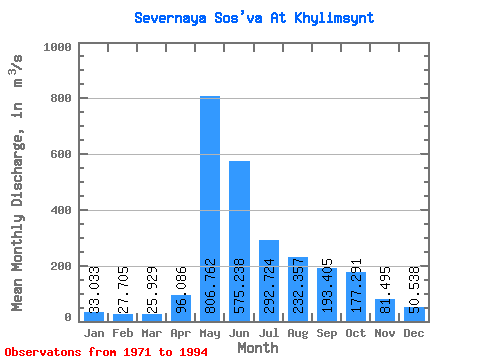
| Statistic | Jan | Feb | Mar | Apr | May | Jun | Jul | Aug | Sep | Oct | Nov | Dec | Annual |
|---|---|---|---|---|---|---|---|---|---|---|---|---|---|
| Mean | 33.03 | 27.70 | 25.93 | 96.09 | 806.76 | 575.24 | 292.72 | 232.36 | 193.41 | 177.29 | 81.50 | 50.54 | 208.41 |
| Standard Deviation | 8.45 | 6.45 | 5.69 | 115.26 | 259.85 | 282.12 | 258.59 | 224.54 | 108.78 | 97.29 | 35.52 | 15.53 | 56.93 |
| Min | 17.70 | 11.60 | 13.10 | 27.40 | 359.00 | 165.00 | 58.50 | 52.10 | 48.70 | 32.00 | 31.00 | 27.80 | 116.42 |
| Max | 51.90 | 42.70 | 38.50 | 417.00 | 1410.00 | 1100.00 | 1110.00 | 784.00 | 451.00 | 404.00 | 157.00 | 82.50 | 321.52 |
| Coefficient of Variation | 0.26 | 0.23 | 0.22 | 1.20 | 0.32 | 0.49 | 0.88 | 0.97 | 0.56 | 0.55 | 0.44 | 0.31 | 0.27 |
 Return to R-Arctic Net Home Page