|
|
|||||||||||||||||
| Point ID: 71 | Downloads | Plots | Site Data | Code: 05AC026 |
|
|
|||||||||||||||||
| Download | |
|---|---|
| Site Descriptor Information | Site Time Series Data |
| Link to all available data | |
| View: | Time Series | All |
| Units: | mm |
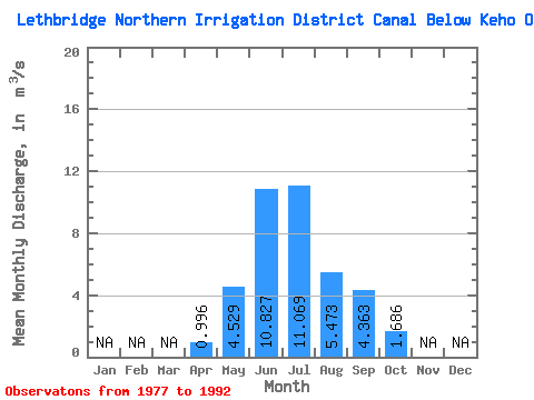
| Statistic | Jan | Feb | Mar | Apr | May | Jun | Jul | Aug | Sep | Oct | Nov | Dec | Annual |
|---|---|---|---|---|---|---|---|---|---|---|---|---|---|
| Mean | 1.00 | 4.53 | 10.83 | 11.07 | 5.47 | 4.36 | 1.69 | ||||||
| Standard Deviation | 0.85 | 4.04 | 4.83 | 4.29 | 1.38 | 2.32 | 1.04 | ||||||
| Min | 0.05 | 0.36 | 2.66 | 2.34 | 2.95 | 1.00 | 0.28 | ||||||
| Max | 1.67 | 13.80 | 16.50 | 19.50 | 7.74 | 10.20 | 3.56 | ||||||
| Coefficient of Variation | 0.85 | 0.89 | 0.45 | 0.39 | 0.25 | 0.53 | 0.62 |
 Return to R-Arctic Net Home Page