|
|
|||||||||||||||||
| Point ID: 7097 | Downloads | Plots | Site Data | Code: 11534 |
|
|
|||||||||||||||||
| Download | |
|---|---|
| Site Descriptor Information | Site Time Series Data |
| Link to all available data | |
| View: | Time Series | All |
| Units: | mm |
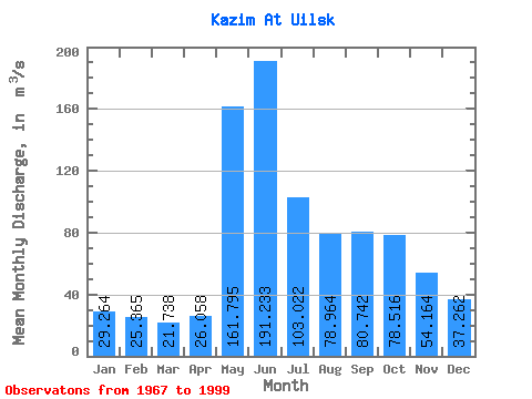
| Statistic | Jan | Feb | Mar | Apr | May | Jun | Jul | Aug | Sep | Oct | Nov | Dec | Annual |
|---|---|---|---|---|---|---|---|---|---|---|---|---|---|
| Mean | 29.26 | 25.36 | 21.74 | 26.06 | 161.79 | 191.23 | 103.02 | 78.96 | 80.74 | 78.52 | 54.16 | 37.26 | 76.73 |
| Standard Deviation | 10.61 | 10.33 | 6.61 | 12.17 | 81.45 | 106.50 | 35.10 | 47.71 | 33.86 | 33.00 | 26.54 | 18.56 | 21.13 |
| Min | 13.50 | 13.30 | 13.00 | 12.20 | 43.80 | 78.60 | 43.50 | 33.90 | 33.70 | 39.00 | 27.50 | 16.00 | 49.81 |
| Max | 65.40 | 67.10 | 44.40 | 72.10 | 324.00 | 442.00 | 188.00 | 217.00 | 140.00 | 170.00 | 133.00 | 102.00 | 112.07 |
| Coefficient of Variation | 0.36 | 0.41 | 0.30 | 0.47 | 0.50 | 0.56 | 0.34 | 0.60 | 0.42 | 0.42 | 0.49 | 0.50 | 0.28 |
 Return to R-Arctic Net Home Page