|
|
|||||||||||||||||
| Point ID: 7093 | Downloads | Plots | Site Data | Code: 11524 |
|
|
|||||||||||||||||
| Download | |
|---|---|
| Site Descriptor Information | Site Time Series Data |
| Link to all available data | |
| View: | Time Series | All |
| Units: | mm |
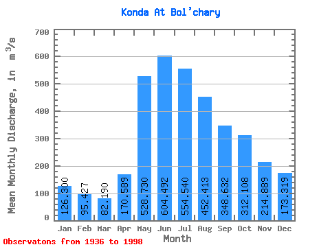
| Statistic | Jan | Feb | Mar | Apr | May | Jun | Jul | Aug | Sep | Oct | Nov | Dec | Annual |
|---|---|---|---|---|---|---|---|---|---|---|---|---|---|
| Mean | 126.30 | 95.43 | 82.19 | 170.59 | 528.73 | 604.49 | 554.54 | 452.41 | 348.63 | 312.11 | 214.89 | 173.32 | 305.30 |
| Standard Deviation | 88.58 | 48.48 | 26.38 | 91.74 | 129.99 | 193.22 | 195.97 | 203.05 | 202.50 | 209.45 | 133.23 | 115.09 | 104.73 |
| Min | 37.20 | 41.60 | 46.50 | 49.60 | 280.00 | 255.00 | 151.00 | 106.00 | 86.90 | 78.50 | 55.90 | 51.00 | 132.00 |
| Max | 472.00 | 307.00 | 174.00 | 597.00 | 998.00 | 1430.00 | 1110.00 | 861.00 | 818.00 | 1180.00 | 711.00 | 568.00 | 624.83 |
| Coefficient of Variation | 0.70 | 0.51 | 0.32 | 0.54 | 0.25 | 0.32 | 0.35 | 0.45 | 0.58 | 0.67 | 0.62 | 0.66 | 0.34 |
 Return to R-Arctic Net Home Page