|
|
|||||||||||||||||
| Point ID: 7084 | Downloads | Plots | Site Data | Code: 11498 |
|
|
|||||||||||||||||
| Download | |
|---|---|
| Site Descriptor Information | Site Time Series Data |
| Link to all available data | |
| View: | Time Series | All |
| Units: | mm |
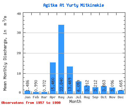
| Statistic | Jan | Feb | Mar | Apr | May | Jun | Jul | Aug | Sep | Oct | Nov | Dec | Annual |
|---|---|---|---|---|---|---|---|---|---|---|---|---|---|
| Mean | 1.49 | 0.99 | 0.97 | 15.46 | 33.84 | 13.47 | 6.06 | 3.91 | 3.21 | 3.86 | 3.10 | 1.67 | 7.33 |
| Standard Deviation | 1.50 | 0.55 | 0.50 | 12.69 | 26.82 | 9.41 | 6.15 | 3.17 | 2.79 | 3.32 | 2.42 | 0.93 | 4.12 |
| Min | 0.51 | 0.41 | 0.40 | 1.47 | 3.43 | 1.32 | 0.78 | 0.62 | 0.62 | 0.63 | 0.48 | 0.52 | 1.22 |
| Max | 9.00 | 2.81 | 2.87 | 54.00 | 130.00 | 36.10 | 30.60 | 12.70 | 11.80 | 13.80 | 10.20 | 4.43 | 17.49 |
| Coefficient of Variation | 1.01 | 0.55 | 0.52 | 0.82 | 0.79 | 0.70 | 1.01 | 0.81 | 0.87 | 0.86 | 0.78 | 0.56 | 0.56 |
 Return to R-Arctic Net Home Page