|
|
|||||||||||||||||
| Point ID: 7077 | Downloads | Plots | Site Data | Code: 11487 |
|
|
|||||||||||||||||
| Download | |
|---|---|
| Site Descriptor Information | Site Time Series Data |
| Link to all available data | |
| View: | Time Series | All |
| Units: | mm |
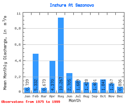
| Statistic | Jan | Feb | Mar | Apr | May | Jun | Jul | Aug | Sep | Oct | Nov | Dec | Annual |
|---|---|---|---|---|---|---|---|---|---|---|---|---|---|
| Mean | 0.74 | 5.33 | 0.67 | 4.37 | 10.27 | 2.71 | 1.69 | 1.43 | 1.40 | 1.84 | 1.27 | 0.84 | 2.72 |
| Standard Deviation | 0.15 | 22.38 | 0.10 | 2.86 | 6.32 | 2.85 | 1.54 | 1.59 | 0.84 | 1.35 | 0.76 | 0.24 | 2.37 |
| Min | 0.50 | 0.44 | 0.50 | 0.65 | 2.03 | 0.88 | 0.54 | 0.60 | 0.67 | 0.58 | 0.60 | 0.52 | 1.43 |
| Max | 0.99 | 108.00 | 0.87 | 9.91 | 25.20 | 14.80 | 7.42 | 8.32 | 3.52 | 5.46 | 3.93 | 1.52 | 12.38 |
| Coefficient of Variation | 0.20 | 4.20 | 0.16 | 0.66 | 0.61 | 1.05 | 0.91 | 1.11 | 0.60 | 0.73 | 0.60 | 0.28 | 0.87 |
 Return to R-Arctic Net Home Page