|
|
|||||||||||||||||
| Point ID: 7059 | Downloads | Plots | Site Data | Code: 11415 |
|
|
|||||||||||||||||
| Download | |
|---|---|
| Site Descriptor Information | Site Time Series Data |
| Link to all available data | |
| View: | Time Series | All |
| Units: | mm |
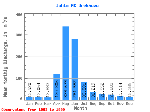
| Statistic | Jan | Feb | Mar | Apr | May | Jun | Jul | Aug | Sep | Oct | Nov | Dec | Annual |
|---|---|---|---|---|---|---|---|---|---|---|---|---|---|
| Mean | 13.92 | 13.06 | 12.88 | 120.81 | 339.68 | 281.55 | 83.58 | 36.22 | 26.55 | 25.69 | 19.11 | 15.39 | 83.12 |
| Standard Deviation | 5.88 | 5.58 | 5.95 | 81.11 | 172.85 | 217.79 | 70.00 | 23.94 | 12.94 | 12.44 | 7.99 | 6.13 | 44.01 |
| Min | 3.32 | 2.42 | 2.32 | 10.40 | 18.90 | 8.43 | 5.50 | 7.08 | 5.19 | 5.35 | 2.74 | 3.40 | 6.74 |
| Max | 27.80 | 22.20 | 24.00 | 370.00 | 646.00 | 712.00 | 321.00 | 133.00 | 68.60 | 51.60 | 35.70 | 31.20 | 173.84 |
| Coefficient of Variation | 0.42 | 0.43 | 0.46 | 0.67 | 0.51 | 0.77 | 0.84 | 0.66 | 0.49 | 0.48 | 0.42 | 0.40 | 0.53 |
 Return to R-Arctic Net Home Page