|
|
|||||||||||||||||
| Point ID: 7058 | Downloads | Plots | Site Data | Code: 11414 |
|
|
|||||||||||||||||
| Download | |
|---|---|
| Site Descriptor Information | Site Time Series Data |
| Link to all available data | |
| View: | Time Series | All |
| Units: | mm |
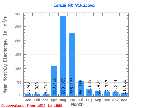
| Statistic | Jan | Feb | Mar | Apr | May | Jun | Jul | Aug | Sep | Oct | Nov | Dec | Annual |
|---|---|---|---|---|---|---|---|---|---|---|---|---|---|
| Mean | 9.75 | 9.33 | 9.78 | 109.46 | 288.08 | 228.13 | 56.14 | 25.69 | 19.48 | 17.72 | 15.24 | 11.66 | 66.70 |
| Standard Deviation | 4.46 | 4.90 | 5.38 | 76.01 | 159.08 | 216.65 | 49.24 | 12.65 | 8.26 | 6.93 | 6.46 | 4.91 | 38.54 |
| Min | 2.38 | 1.89 | 2.13 | 19.90 | 14.90 | 6.21 | 6.29 | 6.16 | 4.07 | 4.26 | 1.05 | 2.22 | 7.08 |
| Max | 23.60 | 24.00 | 25.70 | 343.00 | 568.00 | 846.00 | 304.00 | 53.50 | 38.40 | 38.60 | 29.80 | 24.20 | 175.91 |
| Coefficient of Variation | 0.46 | 0.53 | 0.55 | 0.69 | 0.55 | 0.95 | 0.88 | 0.49 | 0.42 | 0.39 | 0.42 | 0.42 | 0.58 |
 Return to R-Arctic Net Home Page