|
|
|||||||||||||||||
| Point ID: 7050 | Downloads | Plots | Site Data | Code: 11402 |
|
|
|||||||||||||||||
| Download | |
|---|---|
| Site Descriptor Information | Site Time Series Data |
| Link to all available data | |
| View: | Time Series | All |
| Units: | mm |
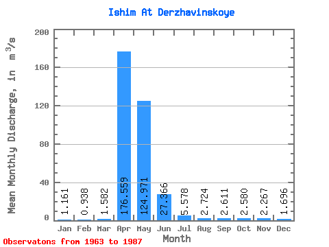
| Statistic | Jan | Feb | Mar | Apr | May | Jun | Jul | Aug | Sep | Oct | Nov | Dec | Annual |
|---|---|---|---|---|---|---|---|---|---|---|---|---|---|
| Mean | 1.16 | 0.94 | 1.58 | 176.56 | 124.97 | 27.37 | 5.58 | 2.72 | 2.61 | 2.58 | 2.27 | 1.70 | 31.65 |
| Standard Deviation | 0.76 | 0.65 | 2.13 | 135.99 | 135.08 | 26.73 | 5.03 | 1.82 | 1.72 | 1.62 | 1.52 | 1.23 | 24.78 |
| Min | 0.12 | 0.07 | 0.20 | 10.10 | 7.61 | 1.50 | 0.30 | 0.04 | 0.12 | 0.17 | 0.15 | 0.01 | 1.89 |
| Max | 3.30 | 2.79 | 10.60 | 407.00 | 582.00 | 92.50 | 19.00 | 9.15 | 7.09 | 7.30 | 5.81 | 4.52 | 84.74 |
| Coefficient of Variation | 0.65 | 0.69 | 1.34 | 0.77 | 1.08 | 0.98 | 0.90 | 0.67 | 0.66 | 0.63 | 0.67 | 0.72 | 0.78 |
 Return to R-Arctic Net Home Page