|
|
|||||||||||||||||
| Point ID: 7049 | Downloads | Plots | Site Data | Code: 11398 |
|
|
|||||||||||||||||
| Download | |
|---|---|
| Site Descriptor Information | Site Time Series Data |
| Link to all available data | |
| View: | Time Series | All |
| Units: | mm |
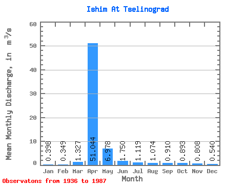
| Statistic | Jan | Feb | Mar | Apr | May | Jun | Jul | Aug | Sep | Oct | Nov | Dec | Annual |
|---|---|---|---|---|---|---|---|---|---|---|---|---|---|
| Mean | 0.40 | 0.35 | 1.33 | 51.04 | 6.98 | 1.75 | 1.12 | 1.07 | 0.91 | 0.89 | 0.81 | 0.54 | 5.57 |
| Standard Deviation | 0.57 | 0.36 | 2.87 | 53.26 | 6.47 | 1.59 | 1.33 | 1.41 | 1.23 | 1.14 | 1.05 | 0.73 | 3.86 |
| Min | 0.00 | 0.01 | 0.00 | 0.52 | 0.14 | 0.04 | 0.01 | 0.02 | 0.04 | 0.03 | 0.03 | 0.02 | 0.71 |
| Max | 2.94 | 1.51 | 11.50 | 242.00 | 24.70 | 5.45 | 5.59 | 5.89 | 5.84 | 5.51 | 5.19 | 3.46 | 14.64 |
| Coefficient of Variation | 1.43 | 1.02 | 2.16 | 1.04 | 0.93 | 0.91 | 1.19 | 1.31 | 1.35 | 1.27 | 1.31 | 1.35 | 0.69 |
 Return to R-Arctic Net Home Page