|
|
|||||||||||||||||
| Point ID: 7047 | Downloads | Plots | Site Data | Code: 11390 |
|
|
|||||||||||||||||
| Download | |
|---|---|
| Site Descriptor Information | Site Time Series Data |
| Link to all available data | |
| View: | Time Series | All |
| Units: | mm |
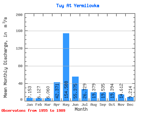
| Statistic | Jan | Feb | Mar | Apr | May | Jun | Jul | Aug | Sep | Oct | Nov | Dec | Annual |
|---|---|---|---|---|---|---|---|---|---|---|---|---|---|
| Mean | 7.15 | 6.13 | 6.06 | 42.37 | 154.59 | 55.38 | 26.73 | 19.38 | 19.54 | 19.39 | 14.61 | 9.21 | 31.27 |
| Standard Deviation | 1.81 | 1.63 | 1.49 | 30.78 | 63.09 | 42.35 | 26.38 | 13.14 | 13.23 | 11.40 | 6.23 | 2.93 | 9.89 |
| Min | 3.72 | 3.02 | 3.53 | 9.03 | 21.10 | 14.00 | 6.51 | 5.67 | 5.42 | 5.41 | 6.10 | 3.97 | 9.91 |
| Max | 11.40 | 9.25 | 8.77 | 123.00 | 297.00 | 213.00 | 157.00 | 59.80 | 64.70 | 58.20 | 31.80 | 17.10 | 52.18 |
| Coefficient of Variation | 0.25 | 0.27 | 0.25 | 0.73 | 0.41 | 0.77 | 0.99 | 0.68 | 0.68 | 0.59 | 0.43 | 0.32 | 0.32 |
 Return to R-Arctic Net Home Page