|
|
|||||||||||||||||
| Point ID: 7022 | Downloads | Plots | Site Data | Code: 11337 |
|
|
|||||||||||||||||
| Download | |
|---|---|
| Site Descriptor Information | Site Time Series Data |
| Link to all available data | |
| View: | Time Series | All |
| Units: | mm |
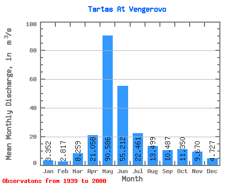
| Statistic | Jan | Feb | Mar | Apr | May | Jun | Jul | Aug | Sep | Oct | Nov | Dec | Annual |
|---|---|---|---|---|---|---|---|---|---|---|---|---|---|
| Mean | 3.35 | 2.82 | 8.26 | 21.06 | 90.59 | 55.21 | 22.46 | 13.50 | 10.49 | 11.35 | 9.67 | 4.73 | 21.19 |
| Standard Deviation | 2.11 | 1.39 | 43.15 | 17.25 | 61.25 | 60.80 | 28.69 | 17.09 | 13.54 | 11.81 | 9.61 | 3.86 | 15.62 |
| Min | 1.10 | 1.13 | 1.27 | 2.60 | 4.52 | 1.15 | 1.18 | 1.13 | 1.86 | 1.95 | 1.33 | 1.39 | 2.35 |
| Max | 11.40 | 7.96 | 334.00 | 93.00 | 254.00 | 293.00 | 141.00 | 99.30 | 92.70 | 46.00 | 40.70 | 18.70 | 69.06 |
| Coefficient of Variation | 0.63 | 0.49 | 5.22 | 0.82 | 0.68 | 1.10 | 1.28 | 1.27 | 1.29 | 1.04 | 0.99 | 0.82 | 0.74 |
 Return to R-Arctic Net Home Page