|
|
|||||||||||||||||
| Point ID: 7010 | Downloads | Plots | Site Data | Code: 11312 |
|
|
|||||||||||||||||
| Download | |
|---|---|
| Site Descriptor Information | Site Time Series Data |
| Link to all available data | |
| View: | Time Series | All |
| Units: | mm |
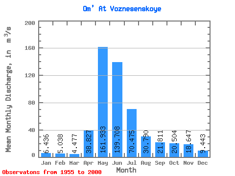
| Statistic | Jan | Feb | Mar | Apr | May | Jun | Jul | Aug | Sep | Oct | Nov | Dec | Annual |
|---|---|---|---|---|---|---|---|---|---|---|---|---|---|
| Mean | 6.44 | 5.04 | 4.48 | 38.83 | 161.93 | 139.71 | 70.47 | 30.79 | 21.81 | 20.50 | 18.65 | 9.44 | 44.02 |
| Standard Deviation | 4.30 | 2.93 | 1.83 | 27.60 | 89.31 | 136.07 | 88.61 | 47.19 | 33.25 | 24.02 | 19.53 | 7.53 | 33.78 |
| Min | 1.82 | 1.48 | 1.59 | 8.16 | 11.00 | 1.92 | 1.95 | 1.74 | 3.56 | 3.29 | 3.30 | 2.18 | 4.34 |
| Max | 23.30 | 16.40 | 9.99 | 132.00 | 359.00 | 459.00 | 343.00 | 234.00 | 191.00 | 121.00 | 94.70 | 40.60 | 145.38 |
| Coefficient of Variation | 0.67 | 0.58 | 0.41 | 0.71 | 0.55 | 0.97 | 1.26 | 1.53 | 1.52 | 1.17 | 1.05 | 0.80 | 0.77 |
 Return to R-Arctic Net Home Page