|
|
|||||||||||||||||
| Point ID: 701 | Downloads | Plots | Site Data | Code: 07CE005 |
|
|
|||||||||||||||||
| Download | |
|---|---|
| Site Descriptor Information | Site Time Series Data |
| Link to all available data | |
| View: | Time Series | All |
| Units: | mm |
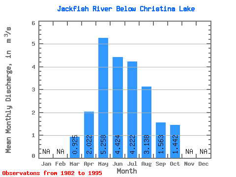
| Statistic | Jan | Feb | Mar | Apr | May | Jun | Jul | Aug | Sep | Oct | Nov | Dec | Annual |
|---|---|---|---|---|---|---|---|---|---|---|---|---|---|
| Mean | 0.93 | 2.02 | 5.26 | 4.42 | 4.22 | 3.14 | 1.56 | 1.44 | |||||
| Standard Deviation | 0.37 | 1.01 | 7.25 | 3.13 | 2.82 | 3.09 | 1.01 | 0.99 | |||||
| Min | 0.24 | 1.09 | 0.54 | 0.63 | 0.46 | 0.46 | 0.26 | 0.36 | |||||
| Max | 1.37 | 4.13 | 26.30 | 11.20 | 10.80 | 11.30 | 3.58 | 3.75 | |||||
| Coefficient of Variation | 0.40 | 0.50 | 1.38 | 0.71 | 0.67 | 0.98 | 0.64 | 0.69 |
 Return to R-Arctic Net Home Page