|
|
|||||||||||||||||
| Point ID: 7008 | Downloads | Plots | Site Data | Code: 11308 |
|
|
|||||||||||||||||
| Download | |
|---|---|
| Site Descriptor Information | Site Time Series Data |
| Link to all available data | |
| View: | Time Series | All |
| Units: | mm |
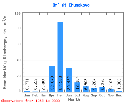
| Statistic | Jan | Feb | Mar | Apr | May | Jun | Jul | Aug | Sep | Oct | Nov | Dec | Annual |
|---|---|---|---|---|---|---|---|---|---|---|---|---|---|
| Mean | 0.77 | 0.53 | 0.45 | 32.84 | 87.37 | 30.43 | 12.16 | 6.91 | 5.28 | 6.08 | 4.11 | 1.38 | 15.87 |
| Standard Deviation | 0.82 | 0.49 | 0.33 | 31.64 | 72.44 | 33.09 | 27.62 | 14.56 | 10.75 | 10.37 | 5.94 | 1.84 | 12.78 |
| Min | 0.08 | 0.04 | 0.06 | 4.06 | 2.57 | 0.49 | 0.19 | 0.16 | 0.17 | 0.25 | 0.23 | 0.17 | 1.36 |
| Max | 3.73 | 2.21 | 1.41 | 138.00 | 262.00 | 128.00 | 156.00 | 69.80 | 54.20 | 44.50 | 22.30 | 9.34 | 48.08 |
| Coefficient of Variation | 1.07 | 0.93 | 0.72 | 0.96 | 0.83 | 1.09 | 2.27 | 2.11 | 2.03 | 1.71 | 1.45 | 1.33 | 0.81 |
 Return to R-Arctic Net Home Page