|
|
|||||||||||||||||
| Point ID: 7000 | Downloads | Plots | Site Data | Code: 11263 |
|
|
|||||||||||||||||
| Download | |
|---|---|
| Site Descriptor Information | Site Time Series Data |
| Link to all available data | |
| View: | Time Series | All |
| Units: | mm |
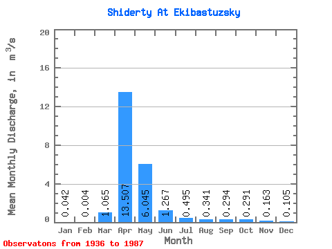
| Statistic | Jan | Feb | Mar | Apr | May | Jun | Jul | Aug | Sep | Oct | Nov | Dec | Annual |
|---|---|---|---|---|---|---|---|---|---|---|---|---|---|
| Mean | 0.04 | 0.00 | 1.06 | 13.51 | 6.04 | 1.27 | 0.49 | 0.34 | 0.29 | 0.29 | 0.16 | 0.10 | 0.54 |
| Standard Deviation | 0.06 | 0.01 | 3.00 | 17.98 | 6.16 | 1.68 | 0.52 | 0.37 | 0.41 | 0.33 | 0.21 | 0.26 | |
| Min | 0.00 | 0.00 | 0.00 | 0.40 | 0.14 | 0.00 | 0.02 | 0.02 | 0.02 | 0.02 | 0.00 | 0.00 | 0.54 |
| Max | 0.13 | 0.01 | 9.05 | 94.30 | 22.20 | 6.42 | 2.29 | 1.68 | 2.09 | 1.54 | 1.04 | 0.95 | 0.54 |
| Coefficient of Variation | 1.42 | 1.32 | 2.81 | 1.33 | 1.02 | 1.33 | 1.06 | 1.09 | 1.39 | 1.13 | 1.32 | 2.46 |
 Return to R-Arctic Net Home Page