|
|
|||||||||||||||||
| Point ID: 6997 | Downloads | Plots | Site Data | Code: 11241 |
|
|
|||||||||||||||||
| Download | |
|---|---|
| Site Descriptor Information | Site Time Series Data |
| Link to all available data | |
| View: | Time Series | All |
| Units: | mm |
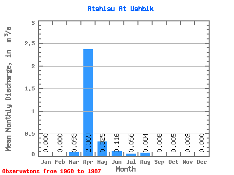
| Statistic | Jan | Feb | Mar | Apr | May | Jun | Jul | Aug | Sep | Oct | Nov | Dec | Annual |
|---|---|---|---|---|---|---|---|---|---|---|---|---|---|
| Mean | 0.00 | 0.00 | 0.09 | 2.37 | 0.33 | 0.12 | 0.06 | 0.08 | 0.01 | 0.01 | 0.00 | 0.00 | 0.05 |
| Standard Deviation | 0.00 | 0.00 | 0.14 | 3.54 | 0.40 | 0.14 | 0.05 | 0.21 | 0.01 | 0.01 | 0.01 | 0.00 | |
| Min | 0.00 | 0.00 | 0.00 | 0.17 | 0.00 | 0.00 | 0.00 | 0.00 | 0.00 | 0.00 | 0.00 | 0.00 | 0.05 |
| Max | 0.00 | 0.00 | 0.40 | 16.40 | 1.19 | 0.47 | 0.16 | 0.60 | 0.02 | 0.02 | 0.01 | 0.00 | 0.05 |
| Coefficient of Variation | 1.51 | 1.49 | 1.22 | 1.24 | 0.97 | 2.50 | 1.19 | 1.61 | 1.62 | 1.73 |
 Return to R-Arctic Net Home Page