|
|
|||||||||||||||||
| Point ID: 6973 | Downloads | Plots | Site Data | Code: 11129 |
|
|
|||||||||||||||||
| Download | |
|---|---|
| Site Descriptor Information | Site Time Series Data |
| Link to all available data | |
| View: | Time Series | All |
| Units: | mm |
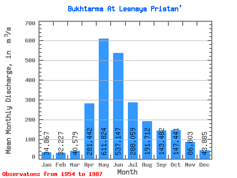
| Statistic | Jan | Feb | Mar | Apr | May | Jun | Jul | Aug | Sep | Oct | Nov | Dec | Annual |
|---|---|---|---|---|---|---|---|---|---|---|---|---|---|
| Mean | 34.87 | 32.23 | 40.58 | 281.44 | 611.82 | 537.15 | 288.06 | 191.71 | 143.48 | 147.44 | 86.80 | 43.88 | 202.74 |
| Standard Deviation | 11.52 | 9.51 | 15.94 | 94.89 | 151.65 | 215.49 | 131.48 | 76.80 | 63.79 | 71.60 | 34.51 | 15.85 | 47.10 |
| Min | 12.10 | 17.60 | 24.90 | 69.60 | 376.00 | 177.00 | 99.00 | 76.60 | 61.70 | 61.20 | 37.90 | 12.60 | 117.17 |
| Max | 60.90 | 55.60 | 90.00 | 465.00 | 904.00 | 948.00 | 639.00 | 323.00 | 323.00 | 326.00 | 176.00 | 74.10 | 307.36 |
| Coefficient of Variation | 0.33 | 0.29 | 0.39 | 0.34 | 0.25 | 0.40 | 0.46 | 0.40 | 0.45 | 0.49 | 0.40 | 0.36 | 0.23 |
 Return to R-Arctic Net Home Page